The problem
Can a model pre-trained on everyday photographs — never once shown a satellite image — be adapted to classify land use from space? 27,000 Sentinel-2 satellite images across 10 categories, from forests to highways to residential areas, were used to find out.
Key results
Why transfer learning, not training from scratch
Training a CNN from scratch means learning everything from zero — including basic visual building blocks like edge and texture detectors, which demand large amounts of data and compute to learn well. A model pre-trained on ImageNet (1.2 million photographs) has already learned excellent general-purpose visual features. This project reuses them directly: a ResNet18 was loaded with its pre-trained weights, every parameter was frozen, and only a new final classification layer — sized for EuroSAT's 10 classes — was trained.
Training and results
Training accuracy rose from 83% in the first epoch to 91.8% by the fifth, converging quickly — expected, given that only a small classifier was being trained on top of already-strong frozen features. On the held-out test set, the model reached 93.19% accuracy, with macro and weighted F1-scores both at 0.93, indicating fairly uniform performance across all 10 classes.
Where the model struggles
Two classes stood out as harder to tell apart: Highway and River. 21 highway images were misclassified as river, while 52 river images were misclassified as highway — a clearly asymmetric confusion.
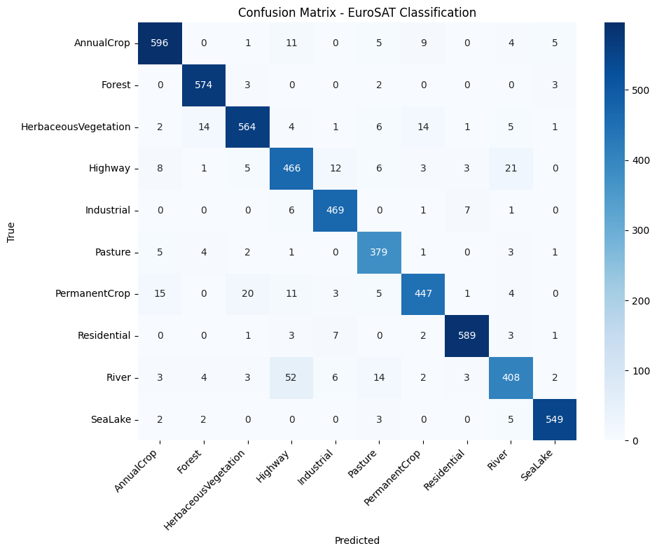
A plausible explanation, rather than a modeling flaw: both highways and rivers tend to appear in satellite imagery as long, narrow, elongated features cutting across the frame — a geometric similarity that could reasonably confuse a model relying on general visual features rather than domain-specific cues (water reflectance, road markings) that a model trained directly on satellite data might exploit more precisely. The asymmetry is intuitive too: a river's winding path more easily resembles a highway's lines than the reverse.